21/09/2024 – Weather in Cornwall – Yellow Weather Warning For Thunderstorms
Yellow Weather Warning in Effect for Cornwall
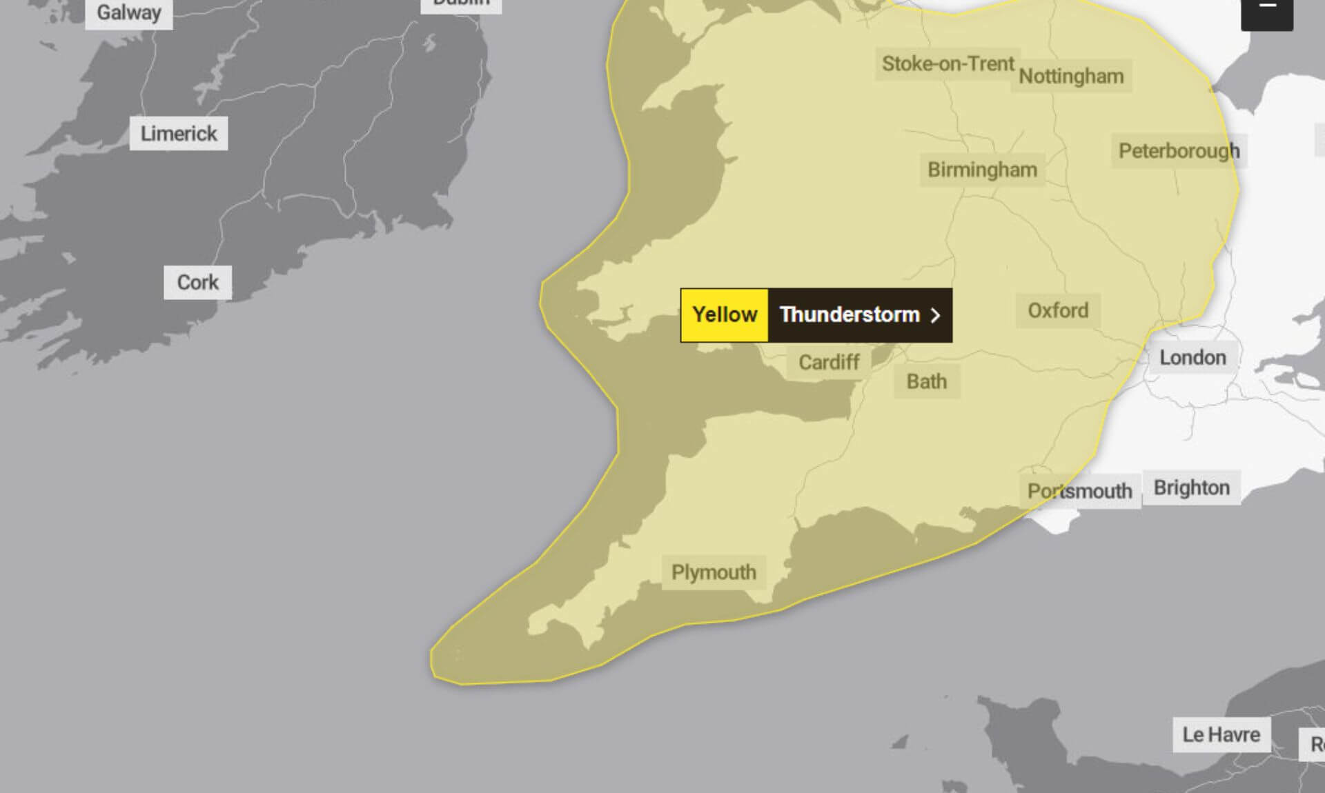
A yellow weather warning for thunderstorms and heavy showers has been issued for today, affecting parts of Cornwall and other areas across southern and western England, as well as east Wales. The warning, issued by the Met Office, is in effect from 01:00 until 23:59 today.
What to Expect
While some places are expected to remain dry, there is a potential for heavy showers and thunderstorms in certain areas throughout the day. This could lead to localised flooding and disruptions. The Met Office has warned of several possible impacts:
- Driving Conditions: Spray and sudden flooding could make driving hazardous, potentially leading to road closures.
- Public Transport: There is a chance of delays or cancellations to train and bus services where flooding or lightning strikes occur.
- Power Cuts: Some homes and businesses may experience power outages, and other essential services could be affected.
- Flooding: There is a risk of rapid flooding of homes and businesses, causing damage to buildings from floodwater, lightning, hail, or strong winds. Fast-flowing or deep floodwater poses a danger to life.
- Isolation of Communities: In some areas, roads may become impassable, cutting off communities temporarily.
Areas Most at Risk
The heaviest showers and most intense thunderstorms are expected during Saturday afternoon and evening, particularly in parts of the Midlands, western England, and east Wales. Accumulations of 20-40 mm of rain in less than an hour are possible, with a small chance of isolated spots seeing up to 80 mm over a few hours. Hail and frequent lightning may also accompany the most severe storms.
How to Stay Safe
The Met Office has advised the public to take precautions to minimise the risk of harm and disruption:
- Check for Flood Risks: If your property is at risk of flooding, consider preparing a flood plan and an emergency flood kit.
- Travel Safely: Check road conditions and public transport timetables before travelling, and amend your plans if necessary. More advice on travelling in severe weather can be found here.
- Prepare for Power Cuts: Gather torches and batteries, a mobile phone power pack, and other essential items in case of power outages. More information on preparing for power cuts is available here.
- Stay Informed: Keep up to date with the latest weather forecasts in your area by checking the Met Office website or app regularly.
Why the Warning is Yellow
The Met Office uses a colour-coded warning system based on the likelihood and impact of weather events. Today’s yellow warning reflects a low likelihood of severe weather but a medium potential impact. This means that while not everyone will experience thunderstorms or flooding, those who do could face significant disruptions.
For more detailed information, visit the Met Office weather warning page.
The warning was last updated at 07:04 this morning to extend it further north and east, while removing southeast England from the affected areas. The likelihood has also been adjusted, and further details have been provided based on the latest information.
Stay safe, and keep an eye on the weather updates throughout the day.
South West England weather forecast
Headline:
A weekend of heavy showers and bright or sunny spells.
Today:
A day of sunshine and showers, occasionally heavy and thundery with strong gusts and hail. Feeling slightly humid but warm in any sunshine with light winds away from the showers. Maximum temperature 22 °C.
Tonight:
Showers lingering in the evening ahead of a more persistent band of rain, possibly with heavy and thundery bursts, pushing northwards overnight. Hill fog over the Moors. Mild and breezy. Minimum temperature 14 °C.
Sunday:
Rain moving across the region to begin. Slightly drier in the afternoon but with the potential for heavy, perhaps thundery, showers to develop as sunny spells emerge. Feeling humid. Maximum temperature 19 °C.
Outlook for Monday to Wednesday:
Turning cooler into the new week. Sunny or bright spells on Monday and Tuesday with a few showers possible. More widely wet and windy from mid-week.
Updated:
Share This Story, Choose Your Platform!
To keep up with the latest cornish news follow us below
Follow CornishStuff on Facebook - Like our Facebook page to get the latest news in your feed and join in the discussions in the comments. Click here to give us a like!
Follow us on Twitter - For the latest breaking news in Cornwall and the latest stories, click here to follow CornishStuff on X.
Follow us on Instagram - We also put the latest news in our Instagram Stories. Click here to follow CornishStuff on Instagram.
You Might Also Be Interested In


Latest News In Cornwall


Daily Cornish news by email
The latest daily news in Cornwall, sent direct to your inbox.


