06/01/2025 – Weather in Cornwall – Yellow Weather Warning For Snow & Ice
The Met Office has issued a Yellow Warning for Snow and Ice from 5:00 pm today until 10:00 am tomorrow, cautioning residents to prepare for potentially hazardous conditions.
What to Expect
Frequent sleet and snow showers are predicted to move across southwest England overnight, with temperatures dropping low enough to cause icy stretches on roads, pavements, and cycle paths. The Met Office warns:
- Travel Disruptions: Longer journey times are likely for roads, buses, and train services.
- Icy Surfaces: Untreated paths and cycle routes may become slippery, increasing the risk of slips and falls.
- Snow Accumulation: Areas above 200 metres could see up to 5 cm of snow in some places, although lower areas may also experience light snowfalls of 0-2 cm.
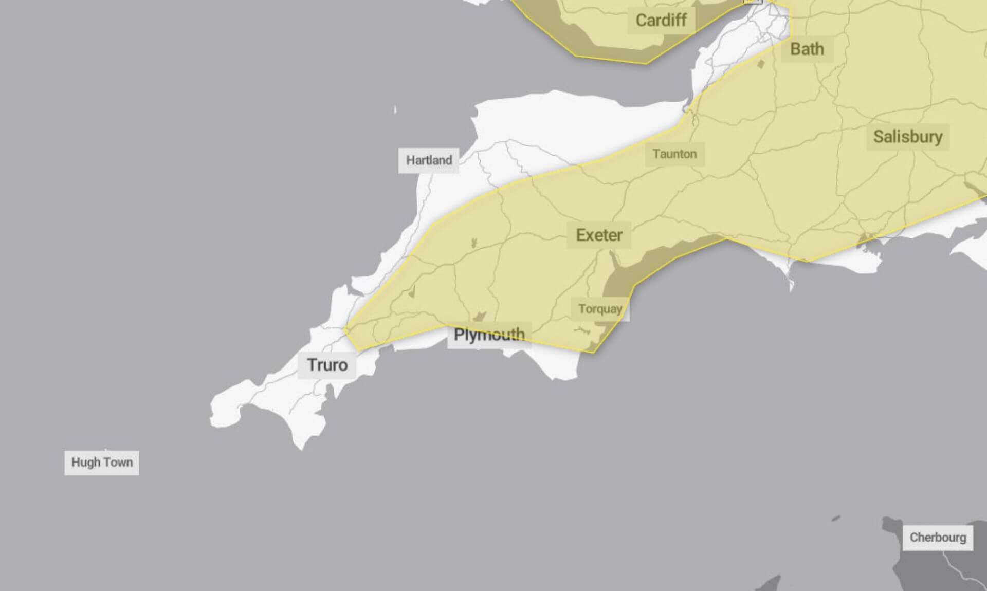
Areas Affected
The weather system will first impact Wales and northwest England this evening, before moving into the South West, Midlands, and parts of southern England in the early hours of Tuesday. Those living at higher altitudes are most likely to see heavier snow showers.
Staying Safe in Icy Conditions
The Met Office advises taking precautions to minimise risks:
- Plan Ahead: Allow extra time for your journey and avoid rushing to reduce the chance of accidents.
- On Foot or Bike: Stick to main roads where possible, as they are more likely to be treated and less icy.
- Essentials for Drivers: If driving, pack items such as warm clothing, a blanket, food, water, a torch, and an ice scraper in case of delays.
Check for Updates
As conditions can change rapidly, the Met Office recommends staying updated with local weather forecasts and checking for travel updates before setting out.
The yellow warning indicates a medium likelihood of disruption but with a low overall impact, underscoring the importance of staying cautious without panic.
South West England weather forecast
Headline:
A cold week ahead with wintry showers and sunny spells.
Today:
Cloud breaking through the day to allow an increasing number of sunny spells. Scattered wintry showers in the west but staying drier further east after early rain clears. Feeling cold in the brisk northwesterly wind. Maximum temperature 6 °C.
Tonight:
Further wintry showers overnight, primarily across Cornwall, Devon and Somerset. Clear spells in between these, under which a patchy rural frost and icy stretches are possible. Staying windy around coasts. Minimum temperature 1 °C.
Tuesday:
A fine day overall with a good number of sunny spells. Scattered wintry showers tending to fade as winds also ease. Cold, with a widespread frost overnight. Maximum temperature 8 °C.
Outlook for Wednesday to Friday:
Remaining cold with further overnight frosts. Rain and snow possible for a time on Wednesday and Friday, with a drier and sunnier day in between on Thursday.
Updated:
Share This Story, Choose Your Platform!
To keep up with the latest cornish news follow us below
Follow CornishStuff on Facebook - Like our Facebook page to get the latest news in your feed and join in the discussions in the comments. Click here to give us a like!
Follow us on Twitter - For the latest breaking news in Cornwall and the latest stories, click here to follow CornishStuff on X.
Follow us on Instagram - We also put the latest news in our Instagram Stories. Click here to follow CornishStuff on Instagram.
You Might Also Be Interested In


Latest News In Cornwall


Daily Cornish news by email
The latest daily news in Cornwall, sent direct to your inbox.


